

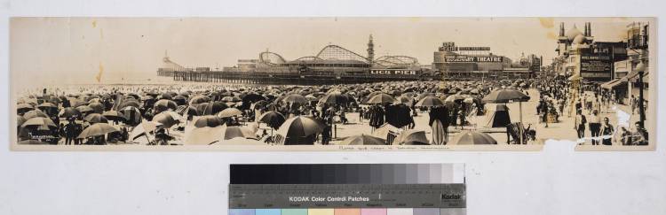
I just found this astonishing panorama and had to share it. You can find the photo on the website for the Huntington Library’s digital archive project. The subject of the photo is the beach next to the Lick Pier that once straddled the southern border of Santa Monica. The detail captured is quite remarkable.
I downloaded a high resolution copy and spent a few minutes exploring it. I found a lot of interesting items. My favorite is the view of what’s now “Boardwalk Yogurt” at 215 Ocean Front Walk. I don’t know what business it was back then, but the original building is still there.
I know the boardwalk used to continue into Santa Monica, but its arrow straightness now ends at the border with Santa Monica. It now follows the curvature of the bike path.

You can see cars parked in the area where they set up the beer garden on weekends. I can’t believe they used to put street lamps right in the middle of Ocean Front Walk. The website says the photo was taken in 1929, but the big sign saying “Tacoma Brew” leads me to believe this photo might have been taken closer to 1920.
