Putin and Obama, who are now on opposing sides of Syria’s bloody civil war, had officially planned no formal sit-downs while in Antalya – just a few hundred miles from Turkey’s border with Syria.
This was really something to see early this morning. You know shit just got real when these two have an impromptu sidebar.
Putin and Obama, who are now on opposing sides of Syria’s bloody civil war, had officially planned no formal sit-downs while in Antalya – just a few hundred miles from Turkey’s border with Syria.
As I’ve mentioned before, one can spend quite a bit of time lost in the digitized photography archives hosted by the digital library at the University of Southern California. It’s the single best resource I’ve found for large- and medium- format Los Angeles photography.
1940 – People frolic on the beach near the roller coaster in the amusement park at Venice Beach
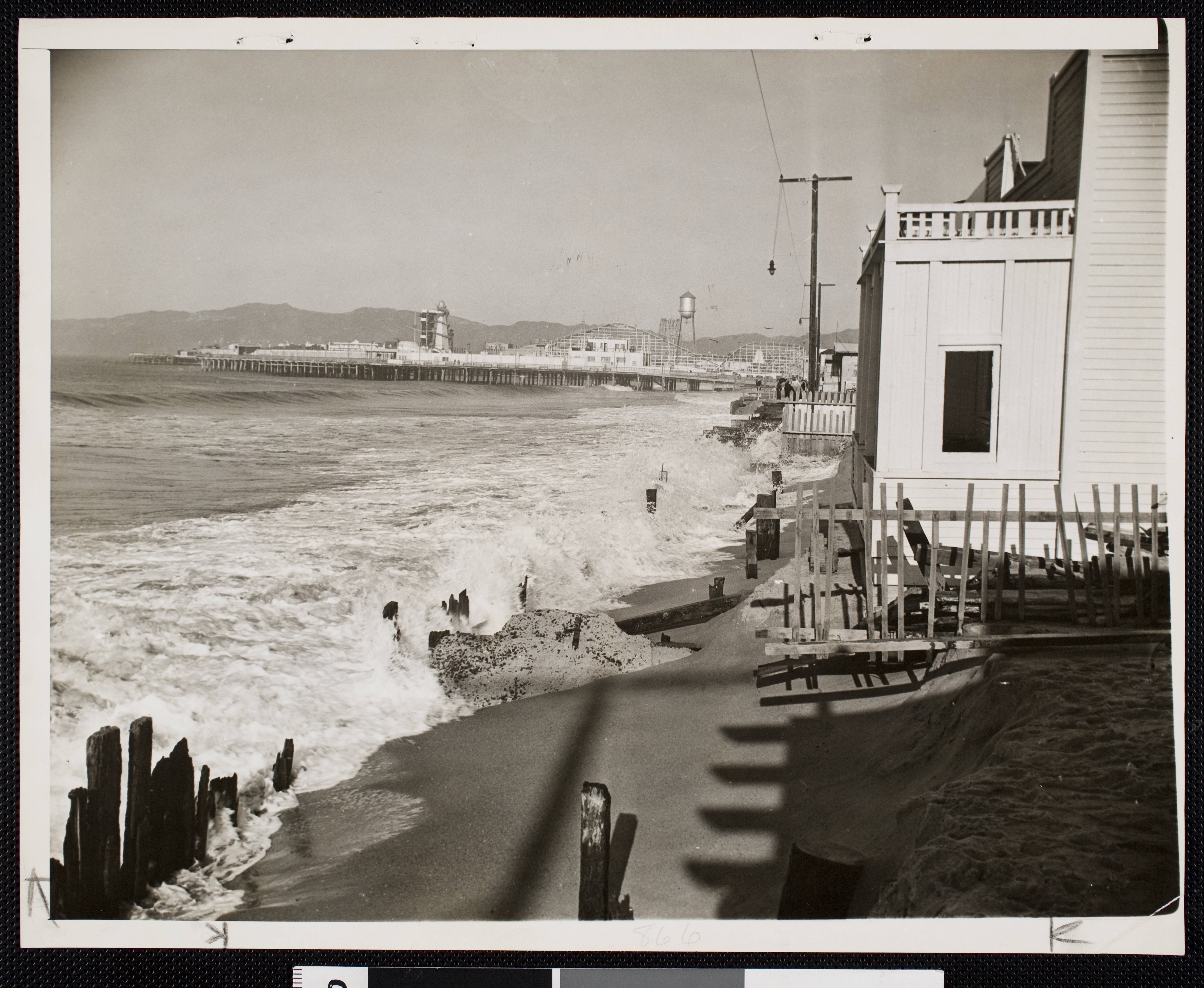
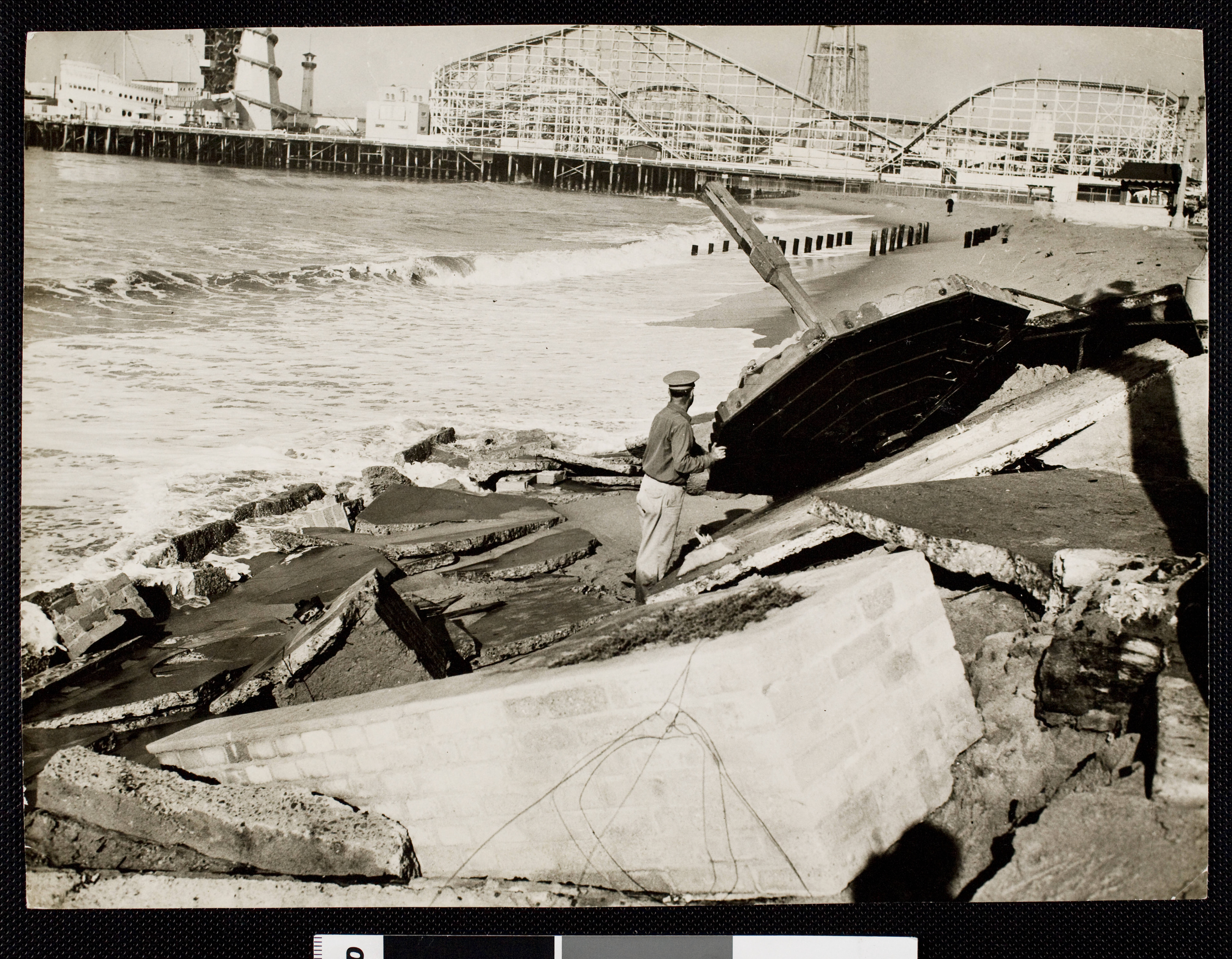
Wherever possible, I try to look for ways to group photographs together. I recently found this same same beach scene is represented in a series of three images from the LA Examiner collection, forming a series of photos spanning three years.
The first photo is from 1940. It shows a healthy broad sand-covered beach. A year later, the beach is gone; not just underwater, but completely washed away.
1941 – Shore line looking north from 25th avenue, Venice, showing damage to beach done by high tides
When viewed together, they illustrate the extent of the erosion that once afflicted the stretch of sand between Windward Avenue and Venice Boulevard. This area, located to the south of the tract owned by the Abbot Kinney Company, was originally known as Short Line Beach. It took its name from the railway that once occupied the center of Venice Boulevard, the “Venice Short Line.”
By 1941, civil engineering blunders had created an ocean current that threatened to strip away the soil from the shore.
1942 – Scene of the tidal damage at Venice
The final photo shows the tidal erosion had crept all the way to Ocean Front Walk, taking with it at least one of the umbrella-shaped sun shades that once lined the pedestrian thoroughfare. I’m sure the war effort – and civil defense planning – hindered attention to this disaster. It’s still something to see it in action.
The stampede occurred in a street between pilgrim camps in Mina [Saudi civil defence handout]Honestly, I don’t believe it. I mean, first off, they’re a terrorist group. And I know the Saudis own a big chunk of Fox; but, I mean — c’mon. How much can this news get filtered, really?
A high-ranking Hezbollah commander told IBT the number of victims is much closer to 4,000.
They say the Saudi Crown Prince who caused it knew that what he was doing. And that they were all Shiite Persians.
Sounds like a casus belli if ever I heard one.
And now I understand the Iranians are letting the Russians use their airspace to attack Daesh targets in Iraq and Syria?
Lines have been drawn.
I’m just going to keep my head down and focus on work!
Another amazing shot by Wayne “Dick” Whittington. The USC Digital Library has a collection of his * ahem * 14,000+ scanned negatives. And they’re all available online.
This photo shows an important subject: the terminus of Santa Monica Boulevard at Ocean Avenue in Santa Monica. This was also a major junction of LA’s famous light rail Pacific Electric metro transit street cars. The Santa Monica line – one of the city’s oldest – travelled down the middle of Santa Monica Boulevard, all the way to Beverly Hills. The right-of-way of the “Lagoon Line”, built at the turn of the century by Moses Sherman, Abbot Kinney, and the LA Pacific Railroad – still exists now as Pacific Avenue in Venice, and once traversed a continuous coastal route (including its own bridge), through Playa del Rey, El Segundo, Manhattan, and Hermosa, finally terminating in Redondo Beach.
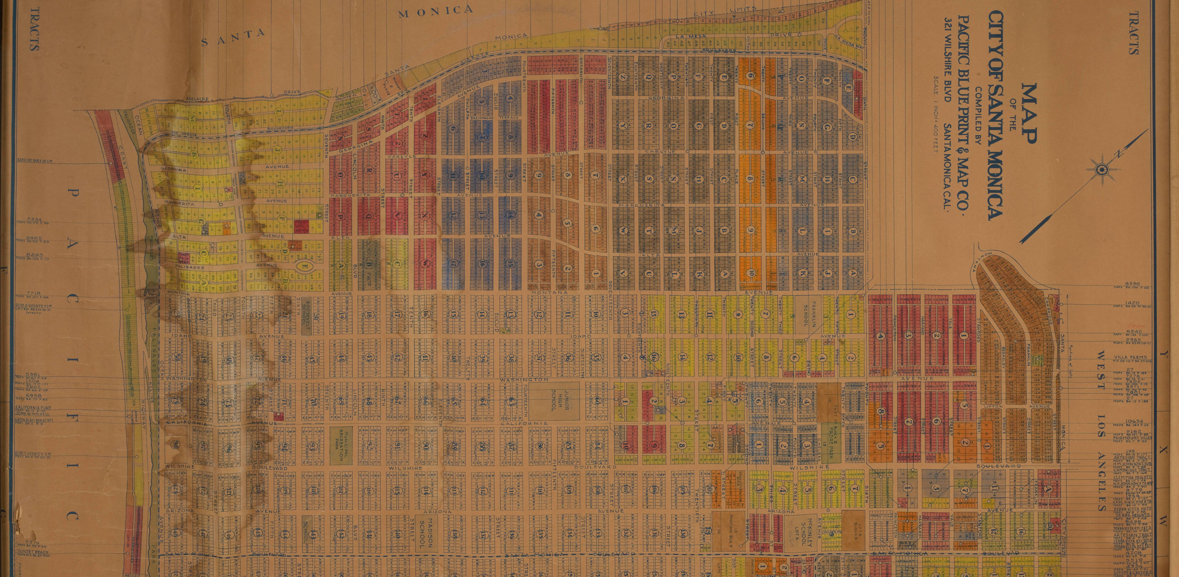
This property map from the 1920s shows the Pacific Electric street car trackage along Ocean Avenue, connecting the Westgate line in Brentwood to the “Santa Monica Line” on Santa Monica Boulevard.
Of significance is the visual indication that a portion of the “North Loop” around downtown Santa Monica, is still intact. This line was ultimately incorporated into the “Westage Line”, the service that would travel up down San Vicente, all the way to the “Old Soldiers’ Home”* (now the grounds of the West L.A. Veterans’ Administration campus) in Sawtelle (now LA’s “West LA”neighborhood).
* NOTE: This line should not to be confused with the Santa Monica & Soldiers‘ Home Railroad, a horse-car line from the Ocean Park neighborhood of Santa Monica, down Nevada Avenue (now Wilshire Boulevard), to its intersection with San Vicente. That line was “electricized” (electrified) around 1900, and its corporate body and assets were ultimately to be acquired by the LAP.


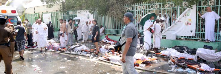
![The stampede occurred in a street between pilgrim camps in Mina [Saudi civil defence handout]](http://cdn.ghanaweb.com/imagelib/pics/98139389.jpg)
 Sounds like a casus belli if ever I heard one.